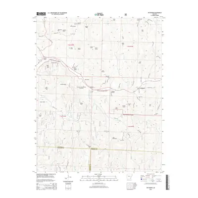
2014 Map of Pettigrew
USGS Topo · Published 2014About this map
The White River and its headwater tributaries, including the E Prong White River and Baldwin Cr, carve through the high elevations of the Ozark National Forest on this modern survey of the Madison County highlands. The small settlements of Dutton and Pettigrew serve as central points in a landscape defined by deep hollows and prominent ridges, such as Watson Ridge and Horn Ridge. For local history researchers, the map identifies several family-named burial sites including Dutton Cem, Watson Cem, and Adkins Cem, which are often the primary remaining markers of early rural communities in this region. The terrain is marked by notable high points like Garrett Mtn and Keck Knob, while the road network is dominated by Ar 16 and Ar 23, following the natural contours of the river valleys. This survey captures the rural character and preservation of the forest lands where Madison, Franklin, and Johnson counties meet.
Find a feature on this map
91 named features on this map. Tap any name to fly to it.
Don’t see what you’re looking for? This feature index may not catch every label — zoom into the map to look around manually.
Map Details
Editions of this 2014 Pettigrew Map
This is the sole edition of this map. No revisions or reprints were ever made.
Other maps of this area

1879 · Cravens
USGS Topo · 1:62,500

1887 · Watalula
USGS Topo · 1:62,500

1906 · Batson
USGS Topo · 1:62,500

1939 · Watalula
USGS Topo · 1:62,500

1943 · St. Paul
USGS Topo · 1:62,500

1946 · St. Paul
USGS Topo · 1:62,500

1956 · Russellville
USGS Topo · 1:250,000

1964 · Russellville
USGS Topo · 1:250,000
1973 · Witter
USGS Topo · 1:24,000
1973 · Boston
USGS Topo · 1:24,000