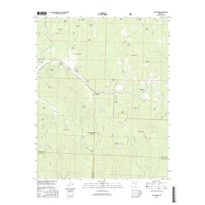
2017 Map of Pettigrew
USGS Topo · Published 2017About this map
Dutton and Pettigrew anchor this mountainous section of the Boston Mountains, where the headwaters of the White River and the E Prong White River have carved deep hollows into the landscape. This 2017 study illustrates a region defined by its dispersed rural cemeteries, which serve as vital markers for family historians tracing surnames like Adkins, Watson, and Kilgore. The map highlights the rugged topography of the Ozark National Forest, showing how modern county roads such as Madison 3169 and Madison 3265 follow the ridges and valleys between Whittmore Mtn and Garrett Mtn. The dense network of small streams, including Baldwin Cr and Kilgore Br, illustrates the complex drainage patterns that have historically dictated the placement of small mountain settlements and local schools in this corner of Madison County.
Find a feature on this map
88 named features on this map. Tap any name to fly to it.
Don’t see what you’re looking for? This feature index may not catch every label — zoom into the map to look around manually.
Map Details
Editions of this 2017 Pettigrew Map
This is the sole edition of this map. No revisions or reprints were ever made.
Other maps of this area

1879 · Cravens
USGS Topo · 1:62,500

1887 · Watalula
USGS Topo · 1:62,500

1906 · Batson
USGS Topo · 1:62,500

1939 · Watalula
USGS Topo · 1:62,500

1943 · St. Paul
USGS Topo · 1:62,500

1946 · St. Paul
USGS Topo · 1:62,500

1956 · Russellville
USGS Topo · 1:250,000

1964 · Russellville
USGS Topo · 1:250,000
1973 · Witter
USGS Topo · 1:24,000
1973 · Boston
USGS Topo · 1:24,000