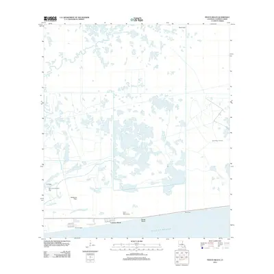
2012 Map of Peveto Beach
USGS Topo · Published 2012About this map
Constance Beach and Peveto Beach line the narrow strip of land between the coastal marshes and the Gulf of Mexico in this early 21st-century survey. The landscape is defined by the intersection of natural ridge lines and energy extraction, with Eli Ridge and McDermott Ridge providing subtle elevation in an otherwise water-dominant environment. The region's industrial character is clear through the extensive presence of fossil fuel infrastructure, including the East Cameron Meadows Gas Field, the Second Bayou Gas Field, and the Ocean View Beach Gas Field. Navigation and drainage are facilitated by features such as the Beach Canal and the winding course of Old-E-Bayou. Small residential pockets like Beach Camp are connected by local routes such as Beach Blvd and Prairie 529, reflecting the sparse but resilient settlement patterns typical of this Louisiana parish coastline.
Find a feature on this map
17 named features on this map. Tap any name to fly to it.
Don’t see what you’re looking for? This feature index may not catch every label — zoom into the map to look around manually.
Map Details
Editions of this 2012 Peveto Beach Map
This is the sole edition of this map. No revisions or reprints were ever made.
Other maps of this area

1934 · Johnsons Bayou
USGS Topo · 1:24,000

1934 · Holly Beach
USGS Topo · 1:24,000

1934 · Peveto Beach
USGS Topo · 1:24,000

1934 · Greens Bayou
USGS Topo · 1:24,000

1934 · Browns Lake
USGS Topo · 1:24,000

1934 · Five Lakes
USGS Topo · 1:24,000

1935 · Peveto Beach
USGS Topo · 1:31,680

1935 · Five Lakes
USGS Topo · 1:31,680

1935 · Holly Beach
USGS Topo · 1:31,680

1935 · Browns Lake
USGS Topo · 1:31,680