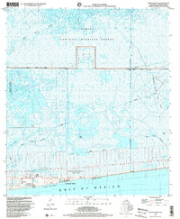
1998 Map of Peveto Beach
USGS Topo · Published 2003About this map
Constance Beach sits at the edge of the Gulf of Mexico, serving as a gateway to the marshy lowlands of the Chenier Plain. This landscape is defined by its ridges, such as Blue Buck Ridge and Eli Ridge, which provided the only dry ground for early settlement and infrastructure in an area dominated by wetlands. Much of the northern portion of the map is protected within the Sabine National Wildlife Refuge, a vast expanse of brackish water and marsh including Old North Bayou.
Find a feature on this map
18 named features on this map. Tap any name to fly to it.
Don’t see what you’re looking for? This feature index may not catch every label — zoom into the map to look around manually.
Map Details
Editions of this 1998 Peveto Beach Map
This is the sole edition of this map. No revisions or reprints were ever made.
Other maps of this area

1934 · Johnsons Bayou
USGS Topo · 1:24,000

1934 · Holly Beach
USGS Topo · 1:24,000

1934 · Peveto Beach
USGS Topo · 1:24,000

1934 · Greens Bayou
USGS Topo · 1:24,000

1934 · Browns Lake
USGS Topo · 1:24,000

1934 · Five Lakes
USGS Topo · 1:24,000

1935 · Peveto Beach
USGS Topo · 1:31,680

1935 · Five Lakes
USGS Topo · 1:31,680

1935 · Holly Beach
USGS Topo · 1:31,680

1935 · Browns Lake
USGS Topo · 1:31,680