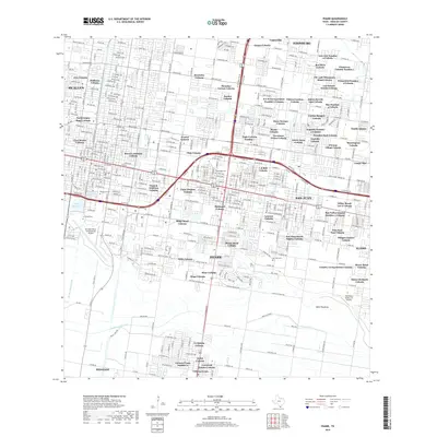
2019 Map of Pharr
USGS Topo · Published 2019About this map
Pharr and eastern McAllen are characterized by a dense, intricate network of residential colonias that defined the Lower Rio Grande Valley landscape in the late 2010s. The map illustrates a unique pattern of unincorporated and annexed neighborhoods, such as Bryan's Addition Colonia and Thrasher Terrace Colonia, which interlock with the established city grids. This period shows significant aviation and industrial infrastructure, ranging from the large Mc Allen Miller International Airport to the smaller Mid-Valley Dusters Inc Airport. The water management system is equally complex, featuring the McAllen Main Canal and the Boeye Reservoir serving the agricultural and urban needs of the region. Local heritage sites like Guadalupe Cem and San Juan Cem remain as physical anchors amidst the rapid residential expansion of Lantana Colonia and Starr Colonia.
Find a feature on this map
124 named features on this map. Tap any name to fly to it.
Don’t see what you’re looking for? This feature index may not catch every label — zoom into the map to look around manually.
Map Details
Editions of this 2019 Pharr Map
This is the sole edition of this map. No revisions or reprints were ever made.
Other maps of this area

1914 · San Juan
USGS Topo · 1:48,000

1916 · San Juan
USGS Topo · 1:62,500

1940 · Monte Christo
USGS Topo · 1:62,500

1949 · Mc Allen
USGS Topo · 1:250,000

1954 · McAllen
USGS Topo · 1:250,000

1957 · Mc Allen
USGS Topo · 1:250,000

1962 · McAllen
USGS Topo · 1:250,000
1962 · San Juan SE
USGS Topo · 1:24,000
1962 · Las Milpas
USGS Topo · 1:24,000

1963 · Edinburg
USGS Topo · 1:24,000