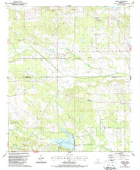
1987 Map of Pheba
USGS Topo · Published 1987About this map
Pheba serves as the central hub of this Mississippi landscape, situated where the Columbus and Greenville railroad crosses the agricultural plains of Clay and Oktibbeha counties. The settlement pattern is defined by rural congregations and family burial grounds, such as Pearsons Chapel Cem and Johnson Creek Ch, which anchored the local community in the late 20th century. The southern portion of the map is dominated by the Oktibbeha County Lake, featuring a Boat Ramp, a Picnic Area, and a Spillway that regulates the flow of Biba Wila Creek. The terrain is intricately drained by numerous waterways including Sun Creek and Double Cabin Creek, highlighting a landscape that remained largely rural and water-dependent decades after its initial mid-century survey.
Find a feature on this map
30 named features on this map. Tap any name to fly to it.
Don’t see what you’re looking for? This feature index may not catch every label — zoom into the map to look around manually.
Map Details
Editions of this 1987 Pheba Map
This is the sole edition of this map. No revisions or reprints were ever made.
Other maps of this area

1953 · West Point
USGS Topo · 1:250,000

1958 · West Point
USGS Topo · 1:250,000

1959 · Pheba
USGS Topo · 1:62,500

1963 · West Point
USGS Topo · 1:250,000

1965 · Starkville
USGS Topo · 1:24,000

1965 · Longview
USGS Topo · 1:24,000

1972 · Maben
USGS Topo · 1:24,000

1972 · Mantee
USGS Topo · 1:24,000

1972 · Double Springs
USGS Topo · 1:24,000

1982 · West Point
USGS Topo · 1:100,000