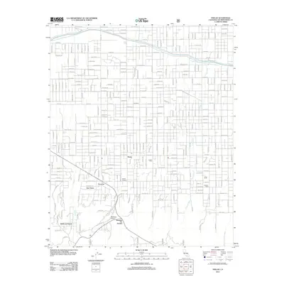
2012 Map of Phelan
USGS Topo · Published 2012About this map
The community of Phelan serves as the focal point of this 2012 survey, revealing a landscape defined by ranching history and modern infrastructure in the High Desert. The northern half of the quadrangle is bisected by the Governor Edmund G Brown California Aqueduct, which cuts a distinct path through a dense grid of residential and ranch roads like La Mesa Rd and Duncan Rd. Notable agricultural and local landmarks are scattered across the terrain, including Goss Ranch, Johnson Ranch, and the Buttemer Ranch.
Find a feature on this map
78 named features on this map. Tap any name to fly to it.
Don’t see what you’re looking for? This feature index may not catch every label — zoom into the map to look around manually.
Map Details
Editions of this 2012 Phelan Map
This is the sole edition of this map. No revisions or reprints were ever made.
Other maps of this area

1901 · Southern California Sheet No. 1
USGS Topo · 1:250,000

1902 · Hesperia
USGS Topo · 1:62,500

1903 · San Antonio
USGS Topo · 1:62,500

1904 · Southern California Sheet No. 1
USGS Topo · 1:250,000

1930 · Angle
USGS Topo · 1:24,000

1932 · Angle
USGS Topo · 1:24,000

1932 · Barstow
USGS Topo · 1:125,000

1934 · Barstow
USGS Topo · 1:125,000
1934 · Boneyard Canyon
USGS Topo · 1:24,000
1936 · Swarthout
USGS Topo · 1:24,000