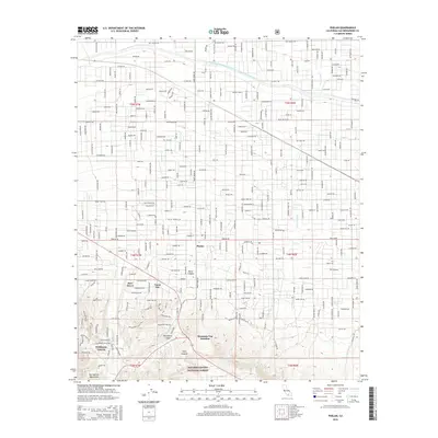
2015 Map of Phelan
USGS Topo · Published 2015About this map
Phelan sits at the high-desert transition between the northern slopes of the San Gabriel Mountains and the Mojave Desert floor. This 2015 survey illustrates a landscape defined by an extensive grid of residential roads, such as Bear Valley Rd and Phelan Rd, that spread across the alluvial fans. The massive infrastructure of the Governor Edmund G. Brown East Branch California Aqueduct cuts horizontally across the northern portion of the map, while the southern boundary reaches into the San Bernardino National Forest. Natural drainages like Sheep Cr and Fremont Wash intersect the developed areas, showing the persistent influence of desert hydrology on local planning. Smaller community nodes like Deer Haven, Yucca Inn, and Mountain Top Junction provide specific points of reference for local historians tracking the growth of this San Bernardino County community.
Find a feature on this map
83 named features on this map. Tap any name to fly to it.
Don’t see what you’re looking for? This feature index may not catch every label — zoom into the map to look around manually.
Map Details
Editions of this 2015 Phelan Map
This is the sole edition of this map. No revisions or reprints were ever made.
Other maps of this area

1901 · Southern California Sheet No. 1
USGS Topo · 1:250,000

1902 · Hesperia
USGS Topo · 1:62,500

1903 · San Antonio
USGS Topo · 1:62,500

1904 · Southern California Sheet No. 1
USGS Topo · 1:250,000

1930 · Angle
USGS Topo · 1:24,000

1932 · Angle
USGS Topo · 1:24,000

1932 · Barstow
USGS Topo · 1:125,000

1934 · Barstow
USGS Topo · 1:125,000
1934 · Boneyard Canyon
USGS Topo · 1:24,000
1936 · Swarthout
USGS Topo · 1:24,000