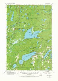
1956 Map of Phelps
USGS Topo · Published 1971About this map
Phelps and Land O'Lakes serve as the primary hubs in this lake-studded borderland during the mid-1950s. The landscape is defined by the transition between the Ottawa National Forest in Michigan and the Nicolet National Forest in Wisconsin, with the state line cutting through the waters of Lac Vieux Desert. The presence of the Katakitckon Indian Village Cem on the northern shore of the lake speaks to the deep indigenous history of the region. Transportation and industry are marked by the Chicago and North Western railroad line, which threads through the dense woodlands past Beaver Station Lake. Strategically placed fire watch stations, including the Imp Lake Lookout Tower and Military Hill Lookout Tower, highlight the ongoing forest management and protection efforts of the era. The mapping of countless smaller bodies of water, from Chickadee Lake to Devils Head Lake, reveals a complex glacial geography prized for its isolation and natural resources.
Find a feature on this map
130 named features on this map. Tap any name to fly to it.
Don’t see what you’re looking for? This feature index may not catch every label — zoom into the map to look around manually.
Map Details
Editions of this 1956 Phelps Map
4 editions found

Other maps of this area

1928 · Three Lakes
USGS Topo · 1:48,000

1930 · Robbins
USGS Topo · 1:48,000

1938 · Phelps
USGS Topo · 1:48,000

1938 · Alvin
USGS Topo · 1:48,000

1938 · Three Lakes
USGS Topo · 1:48,000

1938 · Robbins
USGS Topo · 1:48,000

1945 · Three Lakes
USGS Topo · 1:48,000

1945 · Robbins
USGS Topo · 1:48,000

1946 · Star Lake
USGS Topo · 1:48,000

1946 · Alvin
USGS Topo · 1:48,000