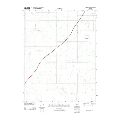
2010 Map of Phenis Creek
USGS Topo · Published 2010About this map
Phenis Creek and the Cottonwood River define the hydraulic character of this Kansas landscape, where the prairie is carved by a network of drainage ways and seasonal streams. The northeastern corner is anchored by the winding path of the river, while the central and southern portions of the sheet are marked by Jacob Creek, Shaw Creek, and Rock Creek. This area of Lyon County is organized around a traditional section-line road grid, including routes such as Johnson Rd and a sequence of numbered roads from Rd 70 to Rd 147. The map illustrates a contemporary rural environment where agriculture and natural watercourses remain the primary features, showing how modern transportation corridors like Road E slice diagonally across the established rectilinear pattern of the 19th-century land survey.
Find a feature on this map
25 named features on this map. Tap any name to fly to it.
Don’t see what you’re looking for? This feature index may not catch every label — zoom into the map to look around manually.
Map Details
Editions of this 2010 Phenis Creek Map
This is the sole edition of this map. No revisions or reprints were ever made.
Other maps of this area

1888 · Emporia
USGS Topo · 1:125,000

1894 · Emporia
USGS Topo · 1:125,000

1955 · Hutchinson
USGS Topo · 1:250,000

1957 · Emporia
USGS Topo · 1:24,000

1957 · Saffordville
USGS Topo · 1:24,000

1957 · Plymouth
USGS Topo · 1:24,000

1959 · Hutchinson
USGS Topo · 1:250,000
1973 · Olpe
USGS Topo · 1:24,000

1973 · Shaw Creek
USGS Topo · 1:24,000
1973 · Gladstone
USGS Topo · 1:24,000