1957 Map of Saffordville
USGS Topo · Published 1958About this map
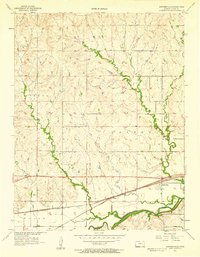
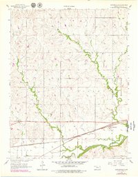
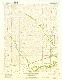
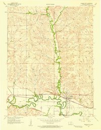
The Cottonwood River floodplain dominates the southern landscape of this 1957 survey, where the Atchison Topeka and Santa Fe railroad runs parallel to the water's edge. This transport corridor facilitated the growth of local shipping points like Saffordville and Ellinor, which served the surrounding agricultural townships of Toledo, Strong, and Falls. North of the river valley, the terrain is defined by a dense network of drainage systems, including the branching paths of Buckeye Creek, East Buckeye Creek, and Bull Creek. Genealogists will find the Hillside Cem located on a rise overlooking the creek valleys, providing a quiet marker of the community's early settlement era. The map clearly illustrates how the rail line dictated the placement of small rural outposts, creating a linear economy tied directly to the river's fertile basin.
Find a feature on this map
14 named features on this map. Tap any name to fly to it.
Don’t see what you’re looking for? This feature index may not catch every label — zoom into the map to look around manually.
Map Details
Editions of this 1957 Saffordville Map
3 editions found
Other maps of this area

1885 · Eskridge
USGS Topo · 1:125,000

1888 · Emporia
USGS Topo · 1:125,000

1889 · Parkerville
USGS Topo · 1:125,000

1889 · Eskridge
USGS Topo · 1:125,000

1894 · Emporia
USGS Topo · 1:125,000

1894 · Eskridge
USGS Topo · 1:125,000

1894 · Parkerville
USGS Topo · 1:125,000

1898 · Cottonwood Falls
USGS Topo · 1:125,000

1955 · Hutchinson
USGS Topo · 1:250,000
1957 · Strong City
USGS Topo · 1:24,000