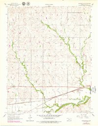
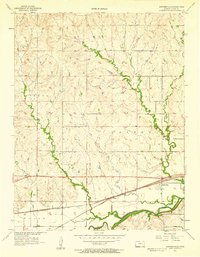
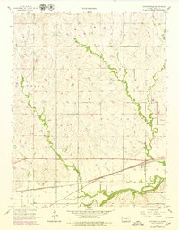
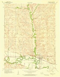
1957 Map of Saffordville
USGS Topo · Published 1978About this map
Saffordville sits as a primary rail settlement along the Atchison Topeka and Santa Fe line, illustrating the critical role of transportation in the Chase County landscape of the late 1950s. The geography is defined by the winding course of the Cottonwood River and its numerous tributaries, including Buckeye Creek, Peyton Creek, and Stout Run, which carve through the townships of Strong and Toledo. The rail corridor is also marked by the location of Ellinor, situated just west of the main settlement. Cultural landmarks like Hillside Cem provide points of interest for genealogists tracing local families in this agricultural region. The map highlights the intersection of water resources and rail infrastructure that drove development in this portion of the Kansas plains.
Find a feature on this map
11 named features on this map. Tap any name to fly to it.
Don’t see what you’re looking for? This feature index may not catch every label — zoom into the map to look around manually.
Map Details
Editions of this 1957 Saffordville Map
3 editions found
Other maps of this area

1885 · Eskridge
USGS Topo · 1:125,000

1888 · Emporia
USGS Topo · 1:125,000

1889 · Parkerville
USGS Topo · 1:125,000

1889 · Eskridge
USGS Topo · 1:125,000

1894 · Emporia
USGS Topo · 1:125,000

1894 · Eskridge
USGS Topo · 1:125,000

1894 · Parkerville
USGS Topo · 1:125,000

1898 · Cottonwood Falls
USGS Topo · 1:125,000

1955 · Hutchinson
USGS Topo · 1:250,000
1957 · Strong City
USGS Topo · 1:24,000