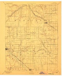
1894 Map of Eskridge
USGS Topo · Published 1894About this map
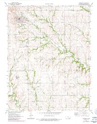
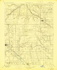
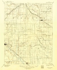
The Neosho River valley serves as a focal point for settlement and transportation in this late nineteenth-century portrait of east-central Kansas. The town of Council Grove dominates the southwest, while a complex web of railroads defines the region's economy and growth. The Chicago Rock Island and Pacific R. R. cuts through the northwest near Templin and Alta Vista, while the Atchison Topeka and Santa Fe Railroad serves Eskridge and Halifax. The terrain is marked by distinctive landmarks like Chalk Mound and an intricate drainage system including the unusually named One Hundred and Forty-two Mile Creek. Small, dispersed communities such as Agnes City, Admire City, and Waushara highlight the early township structure across Wabaunsee and Lyon counties, illustrating the transition from open prairie to an organized agricultural and rail-dependent landscape.
Find a feature on this map
84 named features on this map. Tap any name to fly to it.
Don’t see what you’re looking for? This feature index may not catch every label — zoom into the map to look around manually.
Map Details
Editions of this 1894 Eskridge Map
5 editions found
Historical Maps of Council Grove Through Time
9 maps found