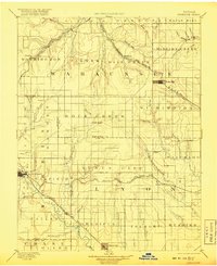
1894 Map of Eskridge
USGS Topo · Published 1918About this map
The intersection of several major nineteenth-century rail lines dominates the rolling prairie of Wabaunsee, Morris, and Lyon counties. Council Grove serves as a primary western hub, while the Atchison Topeka and Santa Fe Railroad and the Chicago Rock Island and Pacific R. R. weave through the northern townships. The landscape is defined by the drainage of Mill Creek and Mission Creek, punctuated by landmarks like Chalk Mound. Small prairie settlements including Eskridge, Americus, and Alta Vista appear as vital stations for the region's ranching and agricultural economy. The survey captures the intricate township structure of Agnes City and Wilmington during a period when the Missouri Pacific Railroad was establishing transit corridors through the central plains, linking the Missouri River valley to the expanding frontier.
Find a feature on this map
85 named features on this map. Tap any name to fly to it.
Don’t see what you’re looking for? This feature index may not catch every label — zoom into the map to look around manually.
Map Details
Editions of this 1894 Eskridge Map
5 editions found

Other maps of this area

1885 · Eskridge
USGS Topo · 1:125,000

1885 · Burlington
USGS Topo · 1:125,000

1886 · Junction City
USGS Topo · 1:125,000

1888 · Emporia
USGS Topo · 1:125,000

1889 · Burlingame
USGS Topo · 1:125,000

1889 · Wamego
USGS Topo · 1:125,000

1889 · Junction City
USGS Topo · 1:125,000

1889 · Parkerville
USGS Topo · 1:125,000

1889 · Eskridge
USGS Topo · 1:125,000

1889 · Topeka
USGS Topo · 1:125,000