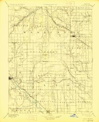
1894 Map of Eskridge
USGS Topo · Published 1927About this map
Council Grove serves as a primary hub in the southwest corner of this region, situated where several creek branches converge toward the Neosho River. This late 19th-century landscape is defined by the expansion of rail networks, including the Atchison Topeka and Santa Fe Railroad and the Chicago Rock Island and Pacific RR, which connect grain elevators and trade centers like Eskridge and Americus. The terrain reveals the transition from the rolling uplands of Chalk Mound to the well-watered valleys of Mill Creek and Mission Creek. Settlement patterns reflect a mix of established townships and small rail-stop communities such as Admire City and Dunlap. Local history is preserved in the detailed grid of rural townships like Agnes City and Wilmington, showing a highly organized agrarian society dependent on the seasonal flow of the numerous named forks and branches that feed the Neosho.
Find a feature on this map
80 named features on this map. Tap any name to fly to it.
Don’t see what you’re looking for? This feature index may not catch every label — zoom into the map to look around manually.
Map Details
Editions of this 1894 Eskridge Map
5 editions found

Other maps of this area

1885 · Eskridge
USGS Topo · 1:125,000

1885 · Burlington
USGS Topo · 1:125,000

1886 · Junction City
USGS Topo · 1:125,000

1888 · Emporia
USGS Topo · 1:125,000

1889 · Burlingame
USGS Topo · 1:125,000

1889 · Wamego
USGS Topo · 1:125,000

1889 · Junction City
USGS Topo · 1:125,000

1889 · Parkerville
USGS Topo · 1:125,000

1889 · Eskridge
USGS Topo · 1:125,000

1889 · Topeka
USGS Topo · 1:125,000