
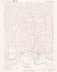
1957 Map of Strong City
USGS Topo · Published 1958About this map
The Cottonwood River meanders sharply across the southern portion of this Chase County landscape, creating a fertile valley where the Atchison Topeka and Santa Fe railroad tracks parallel the water. Near the river junction, Strong City serves as the primary hub, characterized by its grid layout and the nearby Rodeo Grounds. Smaller points of historical interest include the settlement of Neva at the western rail junction and local burial sites like Simmons Cem and St Anthony Cem.
Find a feature on this map
16 named features on this map. Tap any name to fly to it.
Don’t see what you’re looking for? This feature index may not catch every label — zoom into the map to look around manually.
Map Details
Editions of this 1957 Strong City Map
2 editions found
Other maps of this area

1885 · Eskridge
USGS Topo · 1:125,000

1888 · Emporia
USGS Topo · 1:125,000

1889 · Parkerville
USGS Topo · 1:125,000

1889 · Eskridge
USGS Topo · 1:125,000

1894 · Emporia
USGS Topo · 1:125,000

1894 · Eskridge
USGS Topo · 1:125,000

1894 · Parkerville
USGS Topo · 1:125,000

1898 · Cottonwood Falls
USGS Topo · 1:125,000

1955 · Hutchinson
USGS Topo · 1:250,000

1957 · Elmdale
USGS Topo · 1:24,000