1957 Map of Saffordville
USGS Topo · Published 1979About this map
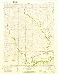
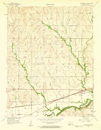
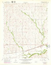
Saffordville and the small settlement of Ellinor sit along the bottomlands of the Cottonwood River, a landscape defined by the heavy infrastructure of the Atchison Topeka and Santa Fe railroad. This 1957 survey, updated with photorevisions in the late 1970s, captures the drainage network of the Flint Hills region, where Buckeye Creek, Peyton Creek, and Bull Creek converge toward the river valley. The map reveals the placement of Hillside Cem on higher ground, overlooking the winding watercourses and the industrial presence of a Spoil Bank near the river. Genealogical researchers can trace the proximity of these rural communities to the rail lines that once fueled the local economy, while the purple photorevision overlays provide a clear visual record of mid-century landscape changes.
Find a feature on this map
14 named features on this map. Tap any name to fly to it.
Don’t see what you’re looking for? This feature index may not catch every label — zoom into the map to look around manually.
Map Details
Editions of this 1957 Saffordville Map
3 editions found
Other maps of this area

1885 · Eskridge
USGS Topo · 1:125,000

1888 · Emporia
USGS Topo · 1:125,000

1889 · Parkerville
USGS Topo · 1:125,000

1889 · Eskridge
USGS Topo · 1:125,000

1894 · Emporia
USGS Topo · 1:125,000

1894 · Eskridge
USGS Topo · 1:125,000

1894 · Parkerville
USGS Topo · 1:125,000

1898 · Cottonwood Falls
USGS Topo · 1:125,000

1955 · Hutchinson
USGS Topo · 1:250,000
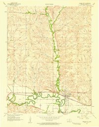
1957 · Strong City
USGS Topo · 1:24,000