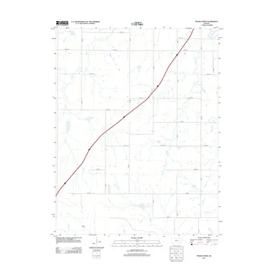
2012 Map of Phenis Creek
USGS Topo · Published 2012About this map
Goessel Cem sits in the southwestern reaches of this Kansas landscape, a quiet landmark amidst a vast network of section roads that define the rural character of Lyon County. The terrain is deeply inscribed by a system of waterways, including Jacob Cr and Rock Cr, which flow through the prairie toward the larger Cottonwood River visible in the northeast corner. This 2012 survey illustrates the enduring agricultural grid, where numbered routes like Road 100 and Road 120 intersect with lettered north-south thoroughfares. The drainage patterns of Phenis Cr and Eagle Cr reveal the subtle undulations of the Flint Hills region, providing a detailed view of the hydrologic network that has dictated land use and settlement since the territory was first organized.
Find a feature on this map
26 named features on this map. Tap any name to fly to it.
Don’t see what you’re looking for? This feature index may not catch every label — zoom into the map to look around manually.
Map Details
Editions of this 2012 Phenis Creek Map
This is the sole edition of this map. No revisions or reprints were ever made.
Other maps of this area

1888 · Emporia
USGS Topo · 1:125,000

1894 · Emporia
USGS Topo · 1:125,000

1955 · Hutchinson
USGS Topo · 1:250,000

1957 · Emporia
USGS Topo · 1:24,000

1957 · Saffordville
USGS Topo · 1:24,000

1957 · Plymouth
USGS Topo · 1:24,000

1959 · Hutchinson
USGS Topo · 1:250,000
1973 · Olpe
USGS Topo · 1:24,000

1973 · Shaw Creek
USGS Topo · 1:24,000
1973 · Gladstone
USGS Topo · 1:24,000