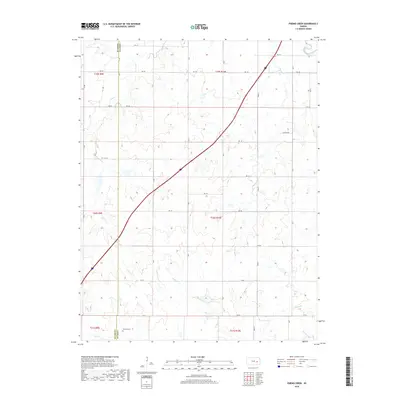
2018 Map of Phenis Creek
USGS Topo · Published 2018About this map
Cottonwood River flows across the northeastern corner of this Flint Hills landscape, where the agricultural grid of Lyon and Chase counties meets a complex drainage system. The terrain is defined by the winding paths of Jacob Cr, Rock Cr, and Phenis Cr, which carve through the limestone-underlain uplands typical of this region. Human presence is marked by a network of rural routes such as Johnson Rd and RD 140, along with the Goessel Cem located in the southwestern corner near the county line. The map captures a moment of modern rural continuity, where traditional section lines persist alongside newer transit corridors. Researchers interested in the hydrology of eastern Kansas can trace the headwaters of Eagle Cr and Moon Br as they feed into the larger river basin.
Find a feature on this map
29 named features on this map. Tap any name to fly to it.
Don’t see what you’re looking for? This feature index may not catch every label — zoom into the map to look around manually.
Map Details
Editions of this 2018 Phenis Creek Map
This is the sole edition of this map. No revisions or reprints were ever made.
Other maps of this area

1888 · Emporia
USGS Topo · 1:125,000

1894 · Emporia
USGS Topo · 1:125,000

1955 · Hutchinson
USGS Topo · 1:250,000

1957 · Emporia
USGS Topo · 1:24,000

1957 · Saffordville
USGS Topo · 1:24,000

1957 · Plymouth
USGS Topo · 1:24,000

1959 · Hutchinson
USGS Topo · 1:250,000
1973 · Olpe
USGS Topo · 1:24,000

1973 · Shaw Creek
USGS Topo · 1:24,000
1973 · Gladstone
USGS Topo · 1:24,000