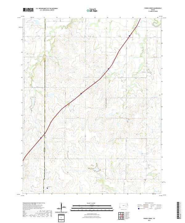
2022 Map of Phenis Creek
USGS Topo · Published 2022About this map
Phenis Creek and its neighboring waterways define this segment of the Kansas landscape along the border of Chase and Lyon counties. The area is characterized by an extensive network of drainages including Jacob Creek, Rock Creek, and Eagle Creek, which feed toward the Cottonwood River in the northeast corner. This modern survey illustrates a rural environment shaped by the Public Land Survey System, with a rigid grid of local roads such as RD 140 and RD 100 carving through the creek valleys. Near the southern edge of the quadrangle, the Goessel Cemetery serves as a significant landmark for genealogists and local historians, anchoring the surrounding agricultural township. The map provides a clear view of the contemporary transport infrastructure, centered on the diagonal corridor of the Kansas Turnpike.
Find a feature on this map
27 named features on this map. Tap any name to fly to it.
Don’t see what you’re looking for? This feature index may not catch every label — zoom into the map to look around manually.
Map Details
Editions of this 2022 Phenis Creek Map
This is the sole edition of this map. No revisions or reprints were ever made.
Other maps of this area

1888 · Emporia
USGS Topo · 1:125,000

1894 · Emporia
USGS Topo · 1:125,000

1955 · Hutchinson
USGS Topo · 1:250,000

1957 · Emporia
USGS Topo · 1:24,000

1957 · Saffordville
USGS Topo · 1:24,000

1957 · Plymouth
USGS Topo · 1:24,000

1959 · Hutchinson
USGS Topo · 1:250,000
1973 · Olpe
USGS Topo · 1:24,000

1973 · Shaw Creek
USGS Topo · 1:24,000
1973 · Gladstone
USGS Topo · 1:24,000