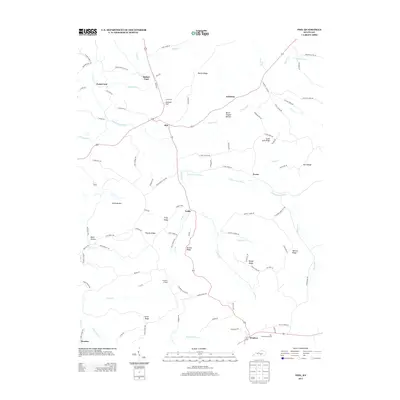
2013 Map of Phil
USGS Topo · Published 2013About this map
The Green River and the South Fork Green River wind through this part of Casey County, where the landscape is defined by long-standing agricultural communities and family-named ridges. High ground like Burton Ridge and Thomas Ridge separates the numerous creek drainages, such as Luttrell Creek and Trace Fork. Local heritage is anchored by sites like Pumpkin Chapel and the small settlements of Phil, Evona, and Teddy. The southern edge of the map features Windsor and a distinct area known as The Flatwoods Section. River crossings such as Evans Ford and Rubert Ford indicate historical travel routes through the valley, while places like Devil Harbor and Bruce Chapel Hollow point to the varied topography that has shaped settlement patterns in this region for generations.
Find a feature on this map
103 named features on this map. Tap any name to fly to it.
Don’t see what you’re looking for? This feature index may not catch every label — zoom into the map to look around manually.
Map Details
Editions of this 2013 Phil Map
This is the sole edition of this map. No revisions or reprints were ever made.
Other maps of this area

1952 · Clementsville
USGS Topo · 1:24,000

1952 · Liberty
USGS Topo · 1:24,000

1952 · Yosemite
USGS Topo · 1:24,000

1953 · Phil
USGS Topo · 1:24,000

1953 · Mintonville
USGS Topo · 1:24,000

1953 · Dunnville
USGS Topo · 1:24,000

1954 · Russell Springs
USGS Topo · 1:24,000

1954 · Eli
USGS Topo · 1:24,000
1954 · Faubush
USGS Topo · 1:24,000

1957 · Winchester
USGS Topo · 1:250,000