
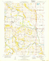
1949 Map of Philadelphia
USGS Topo · Published 1967About this map
Philadelphia serves as a central hub in this rural landscape, situated just north of the winding South Fabius River. The 1940s terrain is defined by a network of local schools and churches that once anchored these Marion County farming communities, such as Prairie Sch and the Little Union Ch. To the south, the topography shifts toward the North Fork South River, where small settlements like Four Corners and Newmarket are documented alongside family-named landmarks. Genealogists will find significant value in the detailed placement of rural burial grounds and educational sites, including the Coleman Cem, Kempf Sch, and the White Franklin Sch. The map preserves the spatial relationship between these vanished or evolved local institutions and the intricate drainage basins of Pigeon Creek and Keller Branch.
Find a feature on this map
30 named features on this map. Tap any name to fly to it.
Don’t see what you’re looking for? This feature index may not catch every label — zoom into the map to look around manually.
Map Details
Editions of this 1949 Philadelphia Map
This is the sole edition of this map. No revisions or reprints were ever made.
Other maps of this area

1903 · Palmyra
USGS Topo · 1:125,000

1948 · Quincy
USGS Topo · 1:250,000

1949 · Durham
USGS Topo · 1:24,000

1949 · Maywood
USGS Topo · 1:24,000

1949 · Palmyra
USGS Topo · 1:24,000
1950 · Maywood
USGS Topo · 1:24,000

1950 · Durham
USGS Topo · 1:24,000

1950 · Palmyra
USGS Topo · 1:24,000

1950 · Philadelphia
USGS Topo · 1:24,000

1956 · Quincy
USGS Topo · 1:250,000