
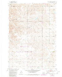
1953 Map of Philip Junction
USGS Topo · Published 1955About this map
Grand View and Little Buffalo characterize the vast, open rangelands of the western plains in this mid-century survey of the South Dakota landscape. The map centers on the high ground north of Kadoka, where a sparse network of section lines and unimproved dirt roads connects isolated ranching interests. This 1953 field check captures a quiet period of rural development in the Missouri River Basin, marked by the intersection of Philip Junction and the presence of the Schimke Sch. The drainage of the S Fk Bad R and the headwaters of Brady Creek define the local hydrology, revealing how topography dictated the early settlement patterns of Jackson and Haakon Counties. For those researching the homesteading history of these prairie uplands, the map provides precise locations for original schoolhouses and rural crossroads long before modern highway realignments.
Find a feature on this map
8 named features on this map. Tap any name to fly to it.
Don’t see what you’re looking for? This feature index may not catch every label — zoom into the map to look around manually.
Map Details
Editions of this 1953 Philip Junction Map
2 editions found
Other maps of this area

1950 · Weta
USGS Topo · 1:24,000

1951 · Kadoka
USGS Topo · 1:24,000

1953 · Philip
USGS Topo · 1:24,000

1953 · Philip SE
USGS Topo · 1:24,000

1954 · Kadoka NE
USGS Topo · 1:24,000

1954 · Pierre
USGS Topo · 1:250,000

1955 · Martin
USGS Topo · 1:250,000

1958 · Pierre
USGS Topo · 1:250,000

1958 · Martin
USGS Topo · 1:250,000

1961 · Cottonwood NE
USGS Topo · 1:24,000