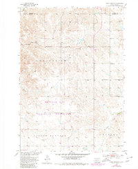
1953 Map of Philip Junction
USGS Topo · Published 1980About this map
Buffalo Gap National Grassland dominates the southern landscape of this West River South Dakota survey, illustrating the vast open grazing lands established during the mid-century. The map centers on the small settlement of Philip Junction, located near the border of Haakon Co and Jackson Co. This terrain is characterized by the erosional patterns of the Little Buffalo and Kadoka regions, where drainage systems like Brady Creek and Fk Bad R have carved intricate contours into the prairie. Local history is anchored by the Schimke Sch in the eastern portion of the quadrangle, a representative one-room schoolhouse that served the dispersed ranching families of the Grand View area. The presence of these small landmarks provides a look at the rural infrastructure supporting the Missouri River Basin development era.
Find a feature on this map
9 named features on this map. Tap any name to fly to it.
Don’t see what you’re looking for? This feature index may not catch every label — zoom into the map to look around manually.
Map Details
Editions of this 1953 Philip Junction Map
2 editions found
Other maps of this area

1950 · Weta
USGS Topo · 1:24,000

1951 · Kadoka
USGS Topo · 1:24,000

1953 · Philip Junction
USGS Topo · 1:24,000

1953 · Philip
USGS Topo · 1:24,000

1953 · Philip SE
USGS Topo · 1:24,000

1954 · Kadoka NE
USGS Topo · 1:24,000

1954 · Pierre
USGS Topo · 1:250,000

1955 · Martin
USGS Topo · 1:250,000

1958 · Pierre
USGS Topo · 1:250,000

1958 · Martin
USGS Topo · 1:250,000