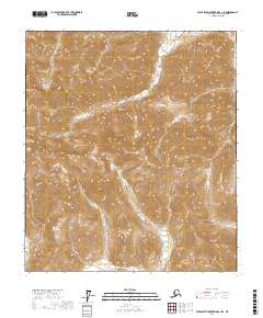
2017 Map of Philip Smith Mountains C-1 SE
USGS Topo · Published 2017About this map
The Philip Smith Mountains dominate this high-latitude terrain, where the crest of the Brooks Range shapes the headwaters of major North Slope drainages. In the northern sections of the sheet, the Ivishak River winds through deeply carved valleys, while the Junjik River drains toward the south, illustrating the Continental Divide's influence on the regional hydrology. The inclusion of the Seejar Glacier in the west-central portion of the quadrangle highlights the persistence of ice in these high elevations during the early 21st century. This survey preserves a detailed record of the township and range boundaries, including t10s r21e and t11s r22e, which define the administrative grid of the Alaska North Slope Borough in this remote wilderness.
Find a feature on this map
10 named features on this map. Tap any name to fly to it.
Don’t see what you’re looking for? This feature index may not catch every label — zoom into the map to look around manually.
Map Details
Editions of this 2017 Philip Smith Mountains C-1 SE Map
This is the sole edition of this map. No revisions or reprints were ever made.
Other maps of this area

1951 · Brooks
USGS Topo · 1:250,000

1951 · Arctic
USGS Topo · 1:250,000

1956 · Arctic
USGS Topo · 1:250,000

1956 · Philip Smith Mountains
USGS Topo · 1:250,000

1964 · Philip Smith Mountains
USGS Topo · 1:250,000
1971 · Philip Smith Mountains C-1
USGS Topo · 1:63,360
1971 · Philip Smith Mountains B-1
USGS Topo · 1:63,360
1971 · Arctic C-5
USGS Topo · 1:63,360
1981 · Arctic B-5
USGS Topo · 1:63,360
2017 · Philip Smith Mountains C-1 SW
USGS Topo · 1:25,000