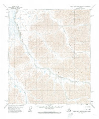
1971 Map of Philip Smith Mountains D-2
USGS Topo · Published 1973About this map
The Saviukviayak River and Lupine River dominate this 1971 Alaskan landscape, where the waterways slice through a series of dramatic mountain ridges. Based on photogrammetric methods from 1970 aerial photography, the map reveals a remote wilderness before significant infrastructure changes. The terrain is marked by prominent features like Lupine and the drainage of Flood Creek, illustrating the natural hydrological patterns of the North Slope. This survey, which was field annotated in 1971 but not field checked, represents a raw topographic record compiled by the U.S. Geological Survey and the USC&GS. It provides a precise view of the braided river channels and sharp contour transitions characteristic of this Arctic mountain range.
Find a feature on this map
4 named features on this map. Tap any name to fly to it.
Don’t see what you’re looking for? This feature index may not catch every label — zoom into the map to look around manually.
Map Details
Editions of this 1971 Philip Smith Mountains D-2 Map
This is the sole edition of this map. No revisions or reprints were ever made.
Other maps of this area

1951 · Sagavanirktok D-5
USGS Topo · 1:250,000

1951 · Brooks
USGS Topo · 1:250,000

1956 · Philip Smith Mountains
USGS Topo · 1:250,000

1956 · Sagavanirktok
USGS Topo · 1:250,000

1958 · Sagavanirktok
USGS Topo · 1:250,000

1964 · Philip Smith Mountains
USGS Topo · 1:250,000

1964 · Sagavanirktok
USGS Topo · 1:250,000
1971 · Sagavanirktok A-1
USGS Topo · 1:63,360
1971 · Philip Smith Mountains D-3
USGS Topo · 1:63,360
1971 · Philip Smith Mountains C-1
USGS Topo · 1:63,360