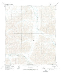
1971 Map of Sagavanirktok A-1
USGS Topo · Published 1973About this map
The Echooka River flows through this remote section of the North Slope, revealing a landscape defined by shifting braided riverbeds and mountainous terrain. Surveyed in the early 1970s, the map captures a vast wilderness area before significant industrial development reached this specific reach of the Arctic. The Ivishak River enters the frame in the southwest, carving through the high country where topographic landmarks like Niviak Pass provide natural corridors through the peaks. Along the northern edge, Gilead Creek winds through the drainage basins, illustrating the complex hydrology of the Brooks Range foothills. This survey by the U.S. Geological Survey was based on 1970 aerial photography, providing a precise record of the land lines and watercourses as they existed in their primary state.
Find a feature on this map
4 named features on this map. Tap any name to fly to it.
Don’t see what you’re looking for? This feature index may not catch every label — zoom into the map to look around manually.
Map Details
Editions of this 1971 Sagavanirktok A-1 Map
This is the sole edition of this map. No revisions or reprints were ever made.
Other maps of this area

1951 · Sagavanirktok D-5
USGS Topo · 1:250,000

1951 · Brooks
USGS Topo · 1:250,000

1951 · Arctic
USGS Topo · 1:250,000

1951 · Mt. Michelson
USGS Topo · 1:250,000

1956 · Arctic
USGS Topo · 1:250,000

1956 · Mt. Michelson
USGS Topo · 1:250,000

1956 · Philip Smith Mountains
USGS Topo · 1:250,000

1956 · Sagavanirktok
USGS Topo · 1:250,000

1958 · Sagavanirktok
USGS Topo · 1:250,000

1964 · Philip Smith Mountains
USGS Topo · 1:250,000