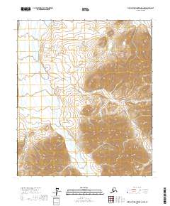
2017 Map of Philip Smith Mountains D-2 NW
USGS Topo · Published 2017About this map
The Saviukviayak River carves a broad valley floor as it flows north through the Brooks Range foothills on this North Slope survey. The watercourse displays a classic braided pattern, shifting across gravel bars and alluvial deposits between rising mountain ridges. In the northeast corner of the sheet, the smaller drainage of Flood Cr emerges from the high peaks. This map illustrates the stark physical geography of the Alaska interior before significant modern development, focusing entirely on the natural drainage systems and the complex topographical contours that dictate the flow of Arctic waters toward the coast.
Find a feature on this map
6 named features on this map. Tap any name to fly to it.
Don’t see what you’re looking for? This feature index may not catch every label — zoom into the map to look around manually.
Map Details
Editions of this 2017 Philip Smith Mountains D-2 NW Map
This is the sole edition of this map. No revisions or reprints were ever made.
Other maps of this area

1951 · Sagavanirktok D-5
USGS Topo · 1:250,000

1951 · Brooks
USGS Topo · 1:250,000

1956 · Philip Smith Mountains
USGS Topo · 1:250,000

1956 · Sagavanirktok
USGS Topo · 1:250,000

1958 · Sagavanirktok
USGS Topo · 1:250,000

1964 · Philip Smith Mountains
USGS Topo · 1:250,000

1964 · Sagavanirktok
USGS Topo · 1:250,000
1971 · Philip Smith Mountains D-3
USGS Topo · 1:63,360
1971 · Philip Smith Mountains D-2
USGS Topo · 1:63,360
1971 · Sagavanirktok A-3
USGS Topo · 1:63,360