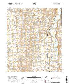
2017 Map of Philip Smith Mountains D-4 NE
USGS Topo · Published 2017About this map
The Sagavanirktok River dominates the eastern portion of this map, its braided channels and gravel bars creating a complex hydrological pattern across the North Slope. Running parallel to this vital waterway are two of the most significant pieces of Alaskan infrastructure: the Alaska Pipeline and the Dalton Highway. This corridor represents the narrow thread of industrial activity and transportation that connects the interior to the northern coast. The surrounding terrain is a mosaic of small lakes and wetlands, typical of the Arctic coastal plain, where the lack of vertical relief and the presence of permafrost dictate the flow of water and the placement of human structures. The map provides a precise record of these features within the survey boundaries of t55s r14e and t6s r14e, showing the proximity of the highway to the pipeline as they navigate the river valley.
Find a feature on this map
7 named features on this map. Tap any name to fly to it.
Don’t see what you’re looking for? This feature index may not catch every label — zoom into the map to look around manually.
Map Details
Editions of this 2017 Philip Smith Mountains D-4 NE Map
This is the sole edition of this map. No revisions or reprints were ever made.
Other maps of this area

1951 · Sagavanirktok D-5
USGS Topo · 1:250,000

1951 · Brooks
USGS Topo · 1:250,000

1956 · Philip Smith Mountains
USGS Topo · 1:250,000

1956 · Sagavanirktok
USGS Topo · 1:250,000

1958 · Sagavanirktok
USGS Topo · 1:250,000

1964 · Philip Smith Mountains
USGS Topo · 1:250,000

1964 · Sagavanirktok
USGS Topo · 1:250,000
1971 · Philip Smith Mountains D-3
USGS Topo · 1:63,360
1971 · Sagavanirktok A-3
USGS Topo · 1:63,360
1971 · Sagavanirktok A-4
USGS Topo · 1:63,360