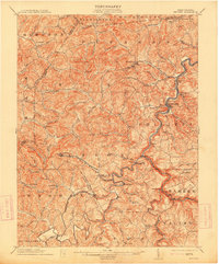
1904 Map of Philippi
USGS Topo · Published 1914About this map
The Tygart River winds through the heart of Barbour County in this early 1900s survey, anchoring a landscape defined by sharp ridges and deep runs. This era shows the critical role of rail transport in the West Virginia hills, with the Baltimore and Ohio RR and Grafton and Belington RR tracing the riverbanks to serve coal and timber interests. The county seat of Philippi appears as the primary hub, surrounded by smaller coal and agricultural settlements like Berryburg, Meriden, and the industrial outpost at Century.
Find a feature on this map
104 named features on this map. Tap any name to fly to it.
Don’t see what you’re looking for? This feature index may not catch every label — zoom into the map to look around manually.
Map Details
Editions of this 1904 Philippi Map
2 editions found
Other maps of this area

1886 · St. George
USGS Topo · 1:125,000

1889 · Beverly
USGS Topo · 1:125,000

1891 · St. George
USGS Topo · 1:125,000

1892 · Beverly
USGS Topo · 1:125,000

1893 · Buckhannon
USGS Topo · 1:125,000

1896 · Buckhannon
USGS Topo · 1:125,000

1897 · Buckhannon
USGS Topo · 1:125,000

1902 · Clarksburg
USGS Topo · 1:62,500

1902 · Fairmont
USGS Topo · 1:62,500

1904 · Philippi
USGS Topo · 1:62,500