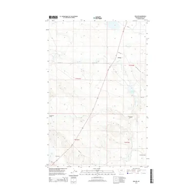
2014 Map of Phillips
USGS Topo · Published 2014About this map
Phillips sits at the intersection of prairie rangeland and the drainages of the Missouri River watershed in Phillips County. This 2014 survey documents a landscape of intermittent waterways and low-lying basins, characterized by the meandering courses of Big Warm Cr and Little Warm Cr. These streams converge near the settlement, while the Little Warm Reservoir provides a critical point of water management for the surrounding ranching operations. The terrain is marked by distinctive coulees and flats that define the local topography, including Schoolhouse Coulee to the west and south, and the broad expanse of Parrot Flat near Parrot Lake. This map captures the essential road network of the High Plains, where Us-191 serves as the primary artery connecting the region, supported by local ranch roads like Hog Ranch Rd and Veseth Rd.
Find a feature on this map
18 named features on this map. Tap any name to fly to it.
Don’t see what you’re looking for? This feature index may not catch every label — zoom into the map to look around manually.
Map Details
Editions of this 2014 Phillips Map
This is the sole edition of this map. No revisions or reprints were ever made.
Other maps of this area

1953 · Havre
USGS Topo · 1:250,000

1954 · Lewistown
USGS Topo · 1:250,000

1957 · Havre
USGS Topo · 1:250,000

1958 · Havre
USGS Topo · 1:250,000

1959 · Lewistown
USGS Topo · 1:250,000

1965 · West Alkali Reservoir
USGS Topo · 1:24,000

1965 · Veseth Reservoir
USGS Topo · 1:24,000

1965 · Phillips
USGS Topo · 1:24,000
1965 · Holzhey Reservoir
USGS Topo · 1:24,000
1965 · Seymour Reservoir
USGS Topo · 1:24,000