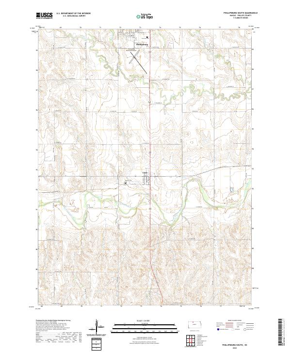
2022 Map of Phillipsburg South
USGS Topo · Published 2022About this map
Phillipsburg sits at the northern edge of this North Central Kansas landscape, where the high plains begin their descent toward the river valley. The agricultural grid is firmly established, intersected by a network of rural roads such as W Santa Fe Rd and W Victory Rd that trace the section lines of the Public Land Survey System. To the south, the settlement of Glade marks the transition toward the riparian corridor of the N Fork Solomon River, which meanders across the lower third of the quadrangle. Local history is anchored by sites like Fairview Cem and Marvin Cem, while the Phillipsburg Municipal Airport and several creek systems, including Deer Cr and Plotner Cr, define the contemporary geography of Phillips County.
Find a feature on this map
31 named features on this map. Tap any name to fly to it.
Don’t see what you’re looking for? This feature index may not catch every label — zoom into the map to look around manually.
Map Details
Editions of this 2022 Phillipsburg South Map
This is the sole edition of this map. No revisions or reprints were ever made.
Other maps of this area

1893 · Phillipsburg
USGS Topo · 1:125,000

1955 · Beloit
USGS Topo · 1:250,000

1959 · Beloit
USGS Topo · 1:250,000

1961 · Kirwin SW
USGS Topo · 1:24,000

1972 · Speed
USGS Topo · 1:24,000

1972 · Glade SW
USGS Topo · 1:24,000

1972 · Kirwin Reservoir
USGS Topo · 1:24,000

1972 · Phillipsburg South
USGS Topo · 1:24,000
1972 · Glade SE
USGS Topo · 1:24,000
1973 · Gretna
USGS Topo · 1:24,000