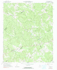
1966 Map of Philomath
USGS Topo · Published 1991About this map
Philomath stands as a focal point in a rural landscape defined by the convergence of Oglethorpe, Wilkes, Greene, and Taliaferro counties. The area is heavily intersected by the upper tributaries of the Little River, including the North Fork and South Fork. Settlement patterns are distinctly concentrated around community institutions such as County Line Ch and New Spring Hill Ch, reflecting the deep-rooted local history of this Georgia interior.
Find a feature on this map
38 named features on this map. Tap any name to fly to it.
Don’t see what you’re looking for? This feature index may not catch every label — zoom into the map to look around manually.
Map Details
Editions of this 1966 Philomath Map
2 editions found
Other maps of this area

1906 · Crawfordville
USGS Topo · 1:125,000

1953 · Athens
USGS Topo · 1:250,000

1958 · Athens
USGS Topo · 1:250,000

1959 · Athens
USGS Topo · 1:250,000

1963 · Athens
USGS Topo · 1:250,000

1965 · Woodville
USGS Topo · 1:24,000

1965 · Union Point
USGS Topo · 1:24,000

1966 · Philomath
USGS Topo · 1:24,000

1966 · Crawfordville
USGS Topo · 1:24,000
1971 · Lexington
USGS Topo · 1:24,000