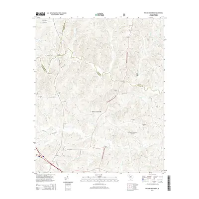
2014 Map of Philson Crossroads
USGS Topo · Published 2014About this map
Philson Crossroads sits at the heart of this landscape where the borders of Laurens, Union, and Spartanburg counties converge. The Enoree River carves a winding path through the northern half of the region, its historical importance to travel and trade evidenced by numerous traditional river crossings like Musgrove Ford, Heads Ford, and Jones Bridge Ford. Much of the eastern and southern terrain is occupied by the protected lands of the Sumter National Forest, creating a mosaic of timberland and small family landmarks.
Find a feature on this map
51 named features on this map. Tap any name to fly to it.
Don’t see what you’re looking for? This feature index may not catch every label — zoom into the map to look around manually.
Map Details
Editions of this 2014 Philson Crossroads Map
This is the sole edition of this map. No revisions or reprints were ever made.
Other maps of this area

1941 · Spartanburg
USGS Topo · 1:250,000

1953 · Spartanburg
USGS Topo · 1:250,000

1960 · Spartanburg
USGS Topo · 1:250,000

1963 · Spartanburg
USGS Topo · 1:250,000

1964 · Spartanburg
USGS Topo · 1:250,000

1969 · Cross Anchor
USGS Topo · 1:24,000

1969 · Ora
USGS Topo · 1:24,000

1969 · Newberry NW
USGS Topo · 1:24,000
1969 · Enoree
USGS Topo · 1:24,000

1969 · Union West
USGS Topo · 1:24,000