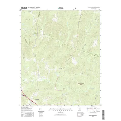
2017 Map of Philson Crossroads
USGS Topo · Published 2017About this map
The intersection of Philson Rd and Barrel Stave Rd defines Philson Crossroads, a central point in this rural South Carolina landscape where Laurens, Spartanburg, and Union counties converge. The Enoree River winds through the northern half of the region, marked by local landmarks like Gordons Mill Falls and Jones Bridge. Much of the southern and eastern territory is occupied by the Sumter National Forest, characterized by a dense network of watercourses including Duncan Creek, Millers Fork, and Beards Fork Cr. For genealogists, the map is a significant record of family-named cemeteries and landmarks, such as Yarboroughs Chapel Cem, Bobo Cem, and Birds Mtn. The southwest corner transitions toward the edge of Clinton, where modern development like Corporate Center Dr meets long-standing rural routes.
Find a feature on this map
53 named features on this map. Tap any name to fly to it.
Don’t see what you’re looking for? This feature index may not catch every label — zoom into the map to look around manually.
Map Details
Editions of this 2017 Philson Crossroads Map
This is the sole edition of this map. No revisions or reprints were ever made.
Other maps of this area

1941 · Spartanburg
USGS Topo · 1:250,000

1953 · Spartanburg
USGS Topo · 1:250,000

1960 · Spartanburg
USGS Topo · 1:250,000

1963 · Spartanburg
USGS Topo · 1:250,000

1964 · Spartanburg
USGS Topo · 1:250,000

1969 · Cross Anchor
USGS Topo · 1:24,000

1969 · Ora
USGS Topo · 1:24,000

1969 · Newberry NW
USGS Topo · 1:24,000
1969 · Enoree
USGS Topo · 1:24,000

1969 · Union West
USGS Topo · 1:24,000