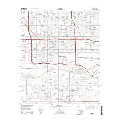
2014 Map of Phoenix
USGS Topo · Published 2014About this map
The dense urban grid of Phoenix is bisected by a network of historic waterways, including the Grand Canal and the branching San Francisco Canal N Br. These irrigation arteries, alongside the Western Canal, trace the city's early agricultural roots even as modern infrastructure like the Phoenix Sky Harbor International Airport and the sprawling campus of Arizona State Univ at the Downtown Phoenix Campus dominate the landscape. For local historians and genealogists, the map preserves the locations of numerous historic burial grounds, from the large Greenwood Memory Lawn Cem to the smaller City Loosley Cem and Cementerio Lindo. The influence of the Southern Pacific RR is evident as it cuts through the valley floor, passing south of the central business district toward the Salt River. Residential expansion is marked by established neighborhoods like Squaw Peak Terrace and Villa Monte Vista, while leisure spaces like Encanto Park and its Encanto Lagoon provide green relief within the desert metropolis.
Find a feature on this map
228 named features on this map. Tap any name to fly to it.
Don’t see what you’re looking for? This feature index may not catch every label — zoom into the map to look around manually.
Map Details
Editions of this 2014 Phoenix Map
This is the sole edition of this map. No revisions or reprints were ever made.
Other maps of this area

1904 · Camelback
USGS Topo · 1:62,500

1906 · Camelsback
USGS Topo · 1:62,500

1912 · Phoenix
USGS Topo · 1:62,500

1913 · Mesa
USGS Topo · 1:62,500

1914 · Phoenix
USGS Topo · 1:62,500

1915 · Mesa
USGS Topo · 1:62,500

1930 · Cave Creek
USGS Topo · 1:125,000

1939 · Cave Creek
USGS Topo · 1:125,000

1952 · Tempe
USGS Topo · 1:24,000

1952 · Lone Butte
USGS Topo · 1:24,000