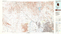
1988 Map of Phoenix North
USGS Topo · Published 1989About this map
The Hassayampa Plain and the Vulture Mountains anchor this late 1980s look at the northwestern reaches of the Valley of the Sun. This era shows the dramatic suburban expansion of Sun City and Glendale, contrasting with the rugged, mineral-focused history of the Wickenburg area to the northwest. The map captures critical infrastructure from the Beardsley Canal to Luke Air Force Base, alongside the legacy of the Vulture Mine and Big Stick Mine. The intricate drainage patterns of Sols Wash and the Agua Fria River illustrate the hydrology that dictated early settlement, while newer developments like Sun City West and Circle City show a landscape undergoing rapid transformation from desert rangeland to a modern metropolitan edge.
Find a feature on this map
58 named features on this map. Tap any name to fly to it.
Don’t see what you’re looking for? This feature index may not catch every label — zoom into the map to look around manually.
Map Details
Editions of this 1988 Phoenix North Map
2 editions found
Other maps of this area

1887 · Verde
USGS Topo · 1:250,000

1887 · Prescott
USGS Topo · 1:250,000

1892 · Verde
USGS Topo · 1:250,000

1892 · Prescott
USGS Topo · 1:250,000

1903 · Bradshaw Mountains
USGS Topo · 1:125,000

1903 · Congress
USGS Topo · 1:125,000

1904 · Camelback
USGS Topo · 1:62,500

1904 · Congress
USGS Topo · 1:125,000

1906 · Camelsback
USGS Topo · 1:62,500

1912 · Phoenix
USGS Topo · 1:62,500