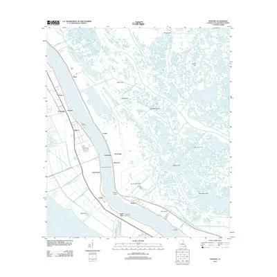
2012 Map of Phoenix
USGS Topo · Published 2012About this map
The Mississippi River carves through the heart of Plaquemines Parish on this 2012 survey, revealing the delicate balance between industrial infrastructure and the wetlands of the delta. Settlements like Alliance, Carlisle, and Ironton are clustered tightly along the river banks, protected by extensive engineering works such as the Alliance Revetment and Harlem Revetment. This pattern of development reflects the historical reliance on the river for transport and the high ground of the natural levees. Beyond the immediate riverside, the landscape transitions into a complex network of waterways, including the Belair Canal, Schayots Canal, and Jim Williams Canal, which service the surrounding marsh and energy infrastructure. Local history is anchored by the Belair Cem and Ironton Cem, while the regional economy is represented by the Spanish Lake Oil Field and Phoenix Gas Field, illustrating the ongoing extraction activities that define this coastal environment.
Find a feature on this map
52 named features on this map. Tap any name to fly to it.
Don’t see what you’re looking for? This feature index may not catch every label — zoom into the map to look around manually.
Map Details
Editions of this 2012 Phoenix Map
This is the sole edition of this map. No revisions or reprints were ever made.
Other maps of this area

1891 · Pointe a La Hache
USGS Topo · 1:62,500

1891 · New Orleans
USGS Topo · 1:62,500

1892 · Barataria
USGS Topo · 1:62,500

1892 · St. Bernard
USGS Topo · 1:62,500

1892 · Pointe a La Hache
USGS Topo · 1:62,500

1932 · New Orleans SE
USGS Topo · 1:31,680

1935 · Delacroix
USGS Topo · 1:31,680

1935 · Lake Batola
USGS Topo · 1:31,680

1939 · Pointe a La Hache
USGS Topo · 1:62,500
1940 · Belle Chasse
USGS Topo · 1:31,680