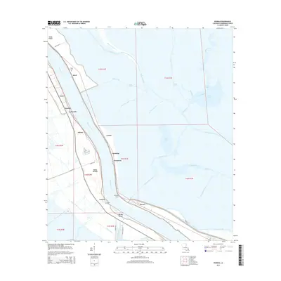
2015 Map of Phoenix
USGS Topo · Published 2015About this map
The Mississippi River carves a deep arc through this portion of Plaquemines Parish, dictating the placement of settlements and the intricate network of drainage canals that define the delta landscape. Historically significant communities like Phoenix, Alliance, and Ironton are situated along the river's western and eastern banks, often adjacent to industrial facilities or sprawling agricultural tracks. The eastern portion of the map transitions into the marshy wetlands of the Louisiana coast, where the River aux Chenes and Spanish Lake represent the delicate balance between fresh and saltwater environments.
Find a feature on this map
48 named features on this map. Tap any name to fly to it.
Don’t see what you’re looking for? This feature index may not catch every label — zoom into the map to look around manually.
Map Details
Editions of this 2015 Phoenix Map
This is the sole edition of this map. No revisions or reprints were ever made.
Other maps of this area

1891 · Pointe a La Hache
USGS Topo · 1:62,500

1891 · New Orleans
USGS Topo · 1:62,500

1892 · Barataria
USGS Topo · 1:62,500

1892 · St. Bernard
USGS Topo · 1:62,500

1892 · Pointe a La Hache
USGS Topo · 1:62,500

1932 · New Orleans SE
USGS Topo · 1:31,680

1935 · Delacroix
USGS Topo · 1:31,680

1935 · Lake Batola
USGS Topo · 1:31,680

1939 · Pointe a La Hache
USGS Topo · 1:62,500
1940 · Belle Chasse
USGS Topo · 1:31,680