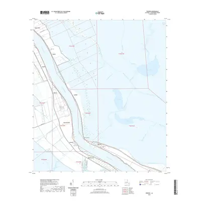
2020 Map of Phoenix
USGS Topo · Published 2020About this map
The Mississippi River carves a deep bend through Plaquemines Parish in this recent study, defining the narrow strip of habitable land where communities like Alliance and Carlisle are situated. To the east, the landscape transitions into a complex network of waterways including River aux Chenes and Spanish Lake, illustrating the fragile hydrology of the Louisiana delta. The map details the vital infrastructure protecting these settlements, most notably the prominent Levy that follows the riverbank, and the extensive drainage systems such as the Forty-Arpent Canal and Belair Canal. Local heritage is anchored by sites like Saint Joseph Cem in Phoenix and the Ironton Cem near Ironton. Along the west bank, the footprint of coastal living is visible from Wills Point down to the docks of Myrtle Grove, where the Wilkinson Canal provides access to the interior marshlands.
Find a feature on this map
50 named features on this map. Tap any name to fly to it.
Don’t see what you’re looking for? This feature index may not catch every label — zoom into the map to look around manually.
Map Details
Editions of this 2020 Phoenix Map
This is the sole edition of this map. No revisions or reprints were ever made.
Other maps of this area

1891 · Pointe a La Hache
USGS Topo · 1:62,500

1891 · New Orleans
USGS Topo · 1:62,500

1892 · Barataria
USGS Topo · 1:62,500

1892 · St. Bernard
USGS Topo · 1:62,500

1892 · Pointe a La Hache
USGS Topo · 1:62,500

1932 · New Orleans SE
USGS Topo · 1:31,680

1935 · Delacroix
USGS Topo · 1:31,680

1935 · Lake Batola
USGS Topo · 1:31,680

1939 · Pointe a La Hache
USGS Topo · 1:62,500
1940 · Belle Chasse
USGS Topo · 1:31,680