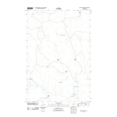
2011 Map of Physic Creek
USGS Topo · Published 2011About this map
Physic Creek and its many tributaries carve through the Prairie County landscape, revealing an intricate network of water management in this part of Montana. The drainage system is characterized by numerous small-scale water control structures, including the Haughan Number 2 Dam, Haughan Number 15 Dam, and Haughan Number 16 Dam, which suggest a history of ranching or agricultural engineering focused on capturing seasonal runoff. Significant landmarks such as Ingersoll Butte and the winding Milwaukee Coulee provide topographical context to the region. The map also documents the Physic Creek Reservoir at the southern end of the sheet, where Physic Creek Dam regulates the flow of the main waterway. This network of dams, including the Reed Number 4 Dam and Reed Number 5 Dam, illustrates the essential relationship between local water sources and the semi-arid terrain.
Find a feature on this map
17 named features on this map. Tap any name to fly to it.
Don’t see what you’re looking for? This feature index may not catch every label — zoom into the map to look around manually.
Map Details
Editions of this 2011 Physic Creek Map
This is the sole edition of this map. No revisions or reprints were ever made.
Other maps of this area

1953 · Miles City
USGS Topo · 1:250,000

1957 · Miles City
USGS Topo · 1:250,000

1958 · Miles City
USGS Topo · 1:250,000

1965 · Little Sheep Mountain
USGS Topo · 1:24,000

1965 · Morehouse Creek
USGS Topo · 1:24,000

1969 · Kinsey NE
USGS Topo · 1:24,000
1969 · Coal Bank Spring
USGS Topo · 1:24,000
1969 · Kinsey NW
USGS Topo · 1:24,000

1972 · Mc Clure Reservoir
USGS Topo · 1:24,000

1972 · Mc Cloud
USGS Topo · 1:24,000