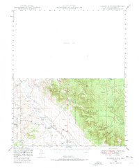
1947 Map of Picacho Butte
USGS Topo · Published 1973About this map
The vast grazing lands and water management systems of Yavapai County define this 1947 survey. Big Chino Wash and its various tributaries, including Partridge Cr and Pine Creek, serve as the primary drainage for the high desert terrain. The area is characterized by isolated agricultural outposts such as K 4 Farm, the CV Ranch, and the Fritsche Ranch, which relied on a network of numerous windmills and tanks to sustain operations. Water infrastructure is notably detailed, featuring Mexican Dam, Cotton Dam, and Limestone Dam, alongside various catchments like Indian Tank and Red Hat Tank. Rising above the surrounding flats, Picacho Butte and South Butte provide significant topographical relief. Evidence of local industry is visible at the Stone Quarry, while a lone telephone line traces a path through the southern portion of the Prescott National Forest.
Find a feature on this map
34 named features on this map. Tap any name to fly to it.
Don’t see what you’re looking for? This feature index may not catch every label — zoom into the map to look around manually.
Map Details
Editions of this 1947 Picacho Butte Map
2 editions found
Other maps of this area

1886 · Chino
USGS Topo · 1:250,000

1887 · Prescott
USGS Topo · 1:250,000

1891 · Chino
USGS Topo · 1:250,000

1892 · Prescott
USGS Topo · 1:250,000

1905 · Jerome
USGS Topo · 1:125,000

1922 · Williams
USGS Topo · 1:125,000

1947 · Ash Fork
USGS Topo · 1:62,500

1947 · Simmons
USGS Topo · 1:62,500

1947 · Picacho Butte
USGS Topo · 1:62,500

1947 · Paulden
USGS Topo · 1:62,500