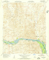
1954 Map of Picacho
USGS Topo · Published 1956About this map
The Trigo Mountains define this rugged corridor of the lower Colorado River basin, where industrial history meets protected desert wetlands. In the mid-1950s, the landscape was primarily divided between the sprawling Yuma Test Station military grounds and the riverfront habitats of the Imperial National Wildlife Refuge. Traces of earlier hard-rock mining are evident throughout the northern mountains, marked by the Red Cloud Mine, Dives Mine, and several shafts near Black Rock Wash. Along the riverbanks, the small settlement of Picacho and the nearby Picacho Mill Ruins stand as evidence of the area's transition from a mining and milling center to a more remote outpost. The complex waterway of the Colorado River is punctuated by significant backwaters like Island Lake and Ferguson Lake, which serve as critical landmarks for both conservation and navigation in the Imperial County and Yuma County borderlands.
Find a feature on this map
32 named features on this map. Tap any name to fly to it.
Don’t see what you’re looking for? This feature index may not catch every label — zoom into the map to look around manually.
Map Details
Editions of this 1954 Picacho Map
This is the sole edition of this map. No revisions or reprints were ever made.
Other maps of this area

1903 · Yuma
USGS Topo · 1:125,000

1905 · Yuma
USGS Topo · 1:125,000

1929 · Laguna
USGS Topo · 1:62,500

1939 · Red Hill
USGS Topo · 1:62,500

1942 · Yuma
USGS Topo · 1:250,000

1942 · Blythe
USGS Topo · 1:250,000

1943 · Laguna
USGS Topo · 1:62,500

1945 · Picacho Peak
USGS Topo · 1:62,500

1945 · Picacho
USGS Topo · 1:62,500

1951 · Picacho
USGS Topo · 1:62,500