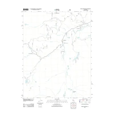
2012 Map of Pickel Meadow
USGS Topo · Published 2012About this map
Pickel Meadow serves as a central hub for this high-altitude landscape where the W Walker River and its various forks shape the terrain. This 2012 survey documents a region defined by recreational access and natural drainage, notably featuring the Leavitt Meadows Lodge Resort and Leavitt Meadows Campground situated near the riverbanks. The map illustrates an intricate network of alpine water bodies and meadows, including Sardine Meadow and Leavitt Meadow, which transition into deep cuts like Yparraquirre Canyon and Kennedy Canyon. To the west, the topography rises toward Wolf Creek Lake and Leavitt Lake, while several named cascades such as Silver Falls and Sardine Falls mark the steep elevation changes. This study provides an essential record of the area's hydrology, tracing numerous tributaries like Cloudburst Cr and Little Wolf Cr as they feed into the primary river system.
Find a feature on this map
35 named features on this map. Tap any name to fly to it.
Don’t see what you’re looking for? This feature index may not catch every label — zoom into the map to look around manually.
Map Details
Editions of this 2012 Pickel Meadow Map
This is the sole edition of this map. No revisions or reprints were ever made.
Other maps of this area

1896 · Dardanelles
USGS Topo · 1:125,000

1898 · Dardanelles
USGS Topo · 1:125,000

1909 · Bridgeport
USGS Topo · 1:125,000

1911 · Bridgeport
USGS Topo · 1:125,000

1920 · Bridgeport
USGS Topo · 1:125,000

1948 · Walker Lake
USGS Topo · 1:250,000

1954 · Chris Flat
USGS Topo · 1:24,000

1954 · Pickel Meadow
USGS Topo · 1:24,000

1954 · Fales Hot Springs
USGS Topo · 1:24,000

1954 · Lost Cannon Peak
USGS Topo · 1:24,000