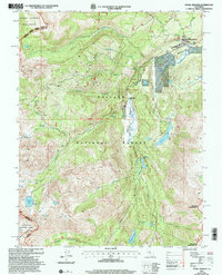
2001 Map of Pickel Meadow
USGS Topo · Published 2004About this map
Pickel Meadow serves as a central high-altitude hub for military training and recreation in the Eastern Sierra, anchored by the USMC Mountain Warfare Sch and its adjacent Landing Strip. This landscape is defined by the headwaters of the West Fork Walker River, which drains a complex basin of glacial lakes including Poore Lake, Leavitt Lake, and Fremont Lake. The transition from the historic Leavitt Sta (Site) to a modern wilderness management area is evident through the convergence of the Carson Iceberg Wilderness, Toiyabe National Forest, and Stanislaus National Forest. The Pacific Crest National Scenic Trail traverses the western ridges, passing near Sardine Falls and Sardine Meadow, reflecting the area's long-standing importance for both trans-Sierra transit and alpine maneuvers at the Mono and Tuolumne county lines.
Find a feature on this map
41 named features on this map. Tap any name to fly to it.
Don’t see what you’re looking for? This feature index may not catch every label — zoom into the map to look around manually.
Map Details
Editions of this 2001 Pickel Meadow Map
This is the sole edition of this map. No revisions or reprints were ever made.
Other maps of this area

1896 · Dardanelles
USGS Topo · 1:125,000

1898 · Dardanelles
USGS Topo · 1:125,000

1909 · Bridgeport
USGS Topo · 1:125,000

1911 · Bridgeport
USGS Topo · 1:125,000

1920 · Bridgeport
USGS Topo · 1:125,000

1948 · Walker Lake
USGS Topo · 1:250,000

1954 · Chris Flat
USGS Topo · 1:24,000

1954 · Pickel Meadow
USGS Topo · 1:24,000

1954 · Fales Hot Springs
USGS Topo · 1:24,000

1954 · Lost Cannon Peak
USGS Topo · 1:24,000