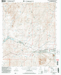
2004 Map of Picketpost Mountain
USGS Topo · Published 2007About this map
Picketpost Mountain dominates the southern landscape of this Pinal County quadrangle, a region defined by its transition from the town of Superior into the expansive Tonto National Forest. The map documents a blend of early 20th-century botanical preservation and historic settlement patterns, most notably the Boyce Thompson Arboretum situated near the Queen Creek Bridge. Researchers will find significant historical evidence in the Old Pinal Townsite, alongside several remote outposts including Hewitt Station, Queens Station, and Millsite Headquarters. The desert terrain is marked by numerous vital water sources like Benson Spring and Millsite Spring, which supported the area's ranching and mining activities. Industrial traces are scattered throughout, with a Quarry and multiple labeled prospects indicating the mineral-rich nature of the mountains near Roblas Butte. This 2004 revision integrates modern planimetry with topography originally compiled in 1945, showing the persistent road and Telephone Line networks through the rugged Picketpost area.
Find a feature on this map
50 named features on this map. Tap any name to fly to it.
Don’t see what you’re looking for? This feature index may not catch every label — zoom into the map to look around manually.
Map Details
Editions of this 2004 Picketpost Mountain Map
This is the sole edition of this map. No revisions or reprints were ever made.
Other maps of this area

1900 · Florence
USGS Topo · 1:125,000

1902 · Florence
USGS Topo · 1:125,000

1948 · Superior
USGS Topo · 1:62,500

1948 · Superior
USGS Topo · 1:24,000

1948 · Iron Mountain
USGS Topo · 1:24,000
1948 · Haunted Canyon
USGS Topo · 1:24,000

1948 · Picketpost Mtn
USGS Topo · 1:24,000

1949 · Superior
USGS Topo · 1:24,000

1949 · Iron Mountain
USGS Topo · 1:24,000
1949 · Haunted Canyon
USGS Topo · 1:24,000