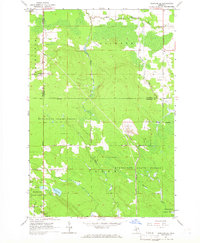
1964 Map of Pickford SE
USGS Topo · Published 1966About this map
The Munuscong State Forest dominates this section of the Upper Peninsula, showing a landscape defined by timber, small-scale resource extraction, and rural settlement. Near the southern edge, the community of Cedarville sits at the junction of State Ave and Pearson Road, serving as a gateway to the Les Cheneaux region. The map details an Industrial Railroad cutting north-south through the forest, a vital link likely supporting the large Quarry located near the center of the sheet.
Find a feature on this map
32 named features on this map. Tap any name to fly to it.
Don’t see what you’re looking for? This feature index may not catch every label — zoom into the map to look around manually.
Map Details
Editions of this 1964 Pickford SE Map
2 editions found
Other maps of this area

1931 · Pickford SE
USGS Topo · 1:31,680

1953 · Munuscong
USGS Topo · 1:24,000

1953 · Pickford NW
USGS Topo · 1:24,000
1953 · Pickford
USGS Topo · 1:24,000

1954 · Sault Sainte Marie
USGS Topo · 1:250,000

1955 · Cheboygan
USGS Topo · 1:250,000

1956 · Sault Sainte Marie
USGS Topo · 1:250,000

1957 · Sault Sainte Marie
USGS Topo · 1:250,000

1958 · Cheboygan
USGS Topo · 1:250,000

1958 · Sault Sainte Marie
USGS Topo · 1:250,000