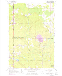
1964 Map of Pickford SE
USGS Topo · Published 1977About this map
The Munuscong State Forest dominates this section of the Upper Peninsula, where the landscape is defined by the transition from wooded lowlands to industrial activity in the mid-1960s. Near the settlement of Cedarville, the land shows significant development with a large Quarry connected to the Industrial Railroad. This rail line and a network of local roads like Winberg Road and Swede Road suggest an era when timber and stone extraction were primary drivers of the local economy.
Find a feature on this map
33 named features on this map. Tap any name to fly to it.
Don’t see what you’re looking for? This feature index may not catch every label — zoom into the map to look around manually.
Map Details
Editions of this 1964 Pickford SE Map
2 editions found
Other maps of this area

1931 · Pickford SE
USGS Topo · 1:31,680

1953 · Munuscong
USGS Topo · 1:24,000

1953 · Pickford NW
USGS Topo · 1:24,000
1953 · Pickford
USGS Topo · 1:24,000

1954 · Sault Sainte Marie
USGS Topo · 1:250,000

1955 · Cheboygan
USGS Topo · 1:250,000

1956 · Sault Sainte Marie
USGS Topo · 1:250,000

1957 · Sault Sainte Marie
USGS Topo · 1:250,000

1958 · Cheboygan
USGS Topo · 1:250,000

1958 · Sault Sainte Marie
USGS Topo · 1:250,000