
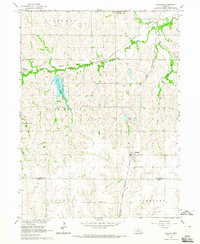
1964 Map of Pickrell
USGS Topo · Published 1965About this map
The Union Pacific railroad corridor serves as the primary industrial artery for this section of Gage County, anchoring the village of Pickrell. This mid-century survey reveals a traditional agrarian landscape organized around the townships of Highland, Nemaha, Holt, and Hanover. The social fabric of the rural community is preserved through a dense network of local landmarks, including several country schools like Island Center Sch and Sherman Center Sch that dot the section lines.
Find a feature on this map
23 named features on this map. Tap any name to fly to it.
Don’t see what you’re looking for? This feature index may not catch every label — zoom into the map to look around manually.
Map Details
Editions of this 1964 Pickrell Map
This is the sole edition of this map. No revisions or reprints were ever made.
Other maps of this area

1897 · Lincoln
USGS Topo · 1:125,000

1955 · Lincoln
USGS Topo · 1:250,000

1957 · Lincoln
USGS Topo · 1:250,000

1957 · Clatonia
USGS Topo · 1:24,000

1957 · Beatrice West
USGS Topo · 1:24,000

1957 · Beatrice East
USGS Topo · 1:24,000

1958 · Lincoln
USGS Topo · 1:250,000

1964 · Cortland
USGS Topo · 1:24,000
1964 · Hallam
USGS Topo · 1:24,000

1965 · Adams
USGS Topo · 1:24,000