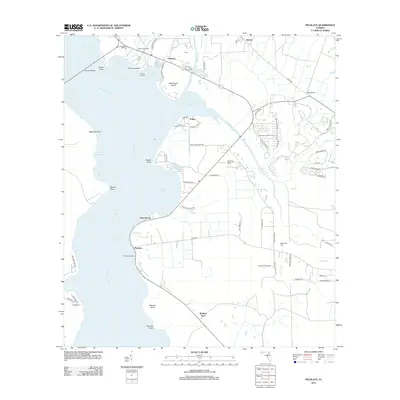
2012 Map of Picolata
USGS Topo · Published 2012About this map
The Saint Johns River dominates the western edge of this landscape, its wide expanse punctuated by landings and points that reflect a long history of river-based commerce and settlement. From the northern crossing at Shands Bridge, the shoreline winds south past Hogarths Landing and Magnolia Landing, leading to the historic riverside community of Picolata. This area serves as a transition between the aquatic activity of the river and the inland agricultural and residential developments of Saint Johns County.
Find a feature on this map
77 named features on this map. Tap any name to fly to it.
Don’t see what you’re looking for? This feature index may not catch every label — zoom into the map to look around manually.
Map Details
Editions of this 2012 Picolata Map
This is the sole edition of this map. No revisions or reprints were ever made.
Other maps of this area

1917 · Orange Park
USGS Topo · 1:62,500

1918 · Orange Park
USGS Topo · 1:62,500

1918 · Palm Valley
USGS Topo · 1:62,500

1937 · Bakersville
USGS Topo · 1:24,000

1937 · Elkton
USGS Topo · 1:24,000

1943 · St. Augustine
USGS Topo · 1:62,500

1947 · Bostwick
USGS Topo · 1:50,000

1948 · Jacksonville
USGS Topo · 1:250,000

1949 · Bostwick
USGS Topo · 1:24,000

1949 · Green Cove Springs
USGS Topo · 1:24,000